Railroads In The 1850s: Mileage, Land Grants, Trunk Lines & the West
Last revised: September 6, 2026
By: Adam Burns
The 1850s are the decade American railroads stopped being a collection of regional experiments and became the country’s main way of moving people and freight over land. They were not yet a single interstate system. Gauges still disagreed. Major rivers still stopped trains. A car from Charleston did not roll onto a New York Central siding. What changed is scale. John Stover’s atlas series, the same figures used on the history hub, put 9,021 miles in operation in 1850. By 1860 the total was on the order of 30,600. Investment, in the same round numbers, went from about $372 million to more than $1.1 billion.
That is the story featured here: land grants and the Illinois Central, four eastern trunks reaching for the Lakes and the Ohio, Chicago as a hub, the first railroad bridge over the Mississippi, Charles Minot’s telegraph train order, California’s first common carrier, and the Pacific surveys that would not be built until the 1860s. The founding years are 1820s/1830s. The kit that made this boom copyable is the 1840s. The war is Civil War railroads. Promontory is the transcontinental.
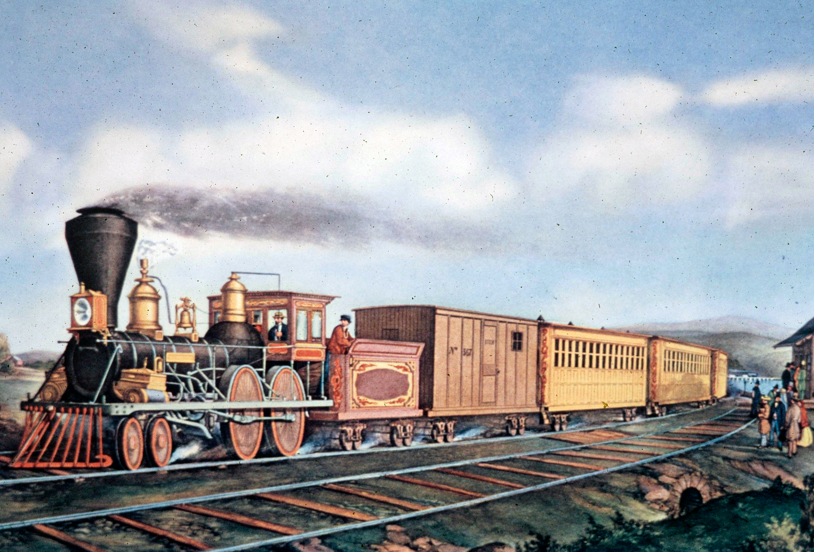
Nathaniel Currier lithograph of an express train, 1855. James Ives did not join the firm until 1857; this sheet is Currier, not Currier & Ives. Author’s collection.
On this page: At a glance · Mileage and money · Land grant and the Illinois Central · Four trunks · Chicago and the rivers · Mississippi bridge · Minot’s train order · California and the surveys · Pullman and the cars · Panic of 1857 · By 1860
At a glance
| Item | Detail |
|---|---|
| Miles in operation, 1850 | 9,021 (Stover / history hub). Period tables also print 9,022 |
| Miles in operation, 1860 | On the order of 30,600 (Poor / census tradition). The hub rounds this as 30,000+. A 1861 figure of 31,246 appears in older site tables |
| Investment (round) | About $372 million (1850) to about $1.15 billion (1860), Stover / McCready–Sagle |
| First federal railroad land grant | Act of September 20, 1850 (Fillmore): Illinois Central in Illinois; Mobile & Ohio in Mississippi and Alabama. Alternate sections. IC charter February 10, 1851 |
| IC Charter Lines | About 705 miles, last spike September 27, 1856: Cairo–Dunleith with the Chicago branch from Centralia |
| New York Central | Ten roads consolidated May 17, 1853, Albany–Buffalo. See New York Central |
| Erie to the Lake | Piermont–Dunkirk opened May 14, 1851 (not Buffalo in 1853). Six-foot gauge. See Erie |
| Ohio River | PRR all-rail Philadelphia–Pittsburgh November 29, 1852 (still using Portage planes over the mountain). B&O to Wheeling January 1, 1853 |
| First train order by telegraph | Charles Minot, Erie, Turner’s (Harriman, N.Y.), September 22, 1851. Morse’s 1844 Washington–Baltimore line is the wire; this is the first dispatch. See pole lines |
| First railroad bridge across the Mississippi | Chicago & Rock Island, Rock Island, Ill.–Davenport, Iowa, April 1856. Steamboat Effie Afton struck it May 6, 1856 |
| Pacific Railroad Surveys | 1853–55, ordered under Secretary of War Jefferson Davis. Several parallel routes. Nothing was built in this decade. Construction is 1862–69 |
Mileage is the Stover / Poor series used on the history hub, not later ICC first-track owned. Regional splits in older site tables (New England/Mid-Atlantic ~5,300; South ~2,100; old Northwest ~1,300 at mid-decade) are order-of-magnitude Stover geography, not a surveyed chainage. Information compiled September 6, 2026.
Mileage and money
Stover’s line is the one worth keeping: by the mid-1850s the United States, with no more than 5 percent of the world’s population, had nearly as much rail mileage as the rest of the world. Few other American institutions did business on so vast a scale or financed themselves in such a variety of ways. T. J. Stiles is right that the railroad became the first American business to employ thousands and capitalize in the millions. That is this decade talking, not the 1820s.
The 1851 map from the American Railway Guide, below, is the picture. The East is webbed. The South is a set of port-to-interior stems, much of it 5-foot gauge. The old Northwest is filling in. Texas and California are footnotes. Nothing yet stitches Omaha to Sacramento. The live copy called this a “fluid interstate system.” You could go farther, and faster: New York to Chicago in about two days on the better connections, against a month at the century’s opening. You still changed cars. You still hit the wrong gauge. You still ferried some rivers.
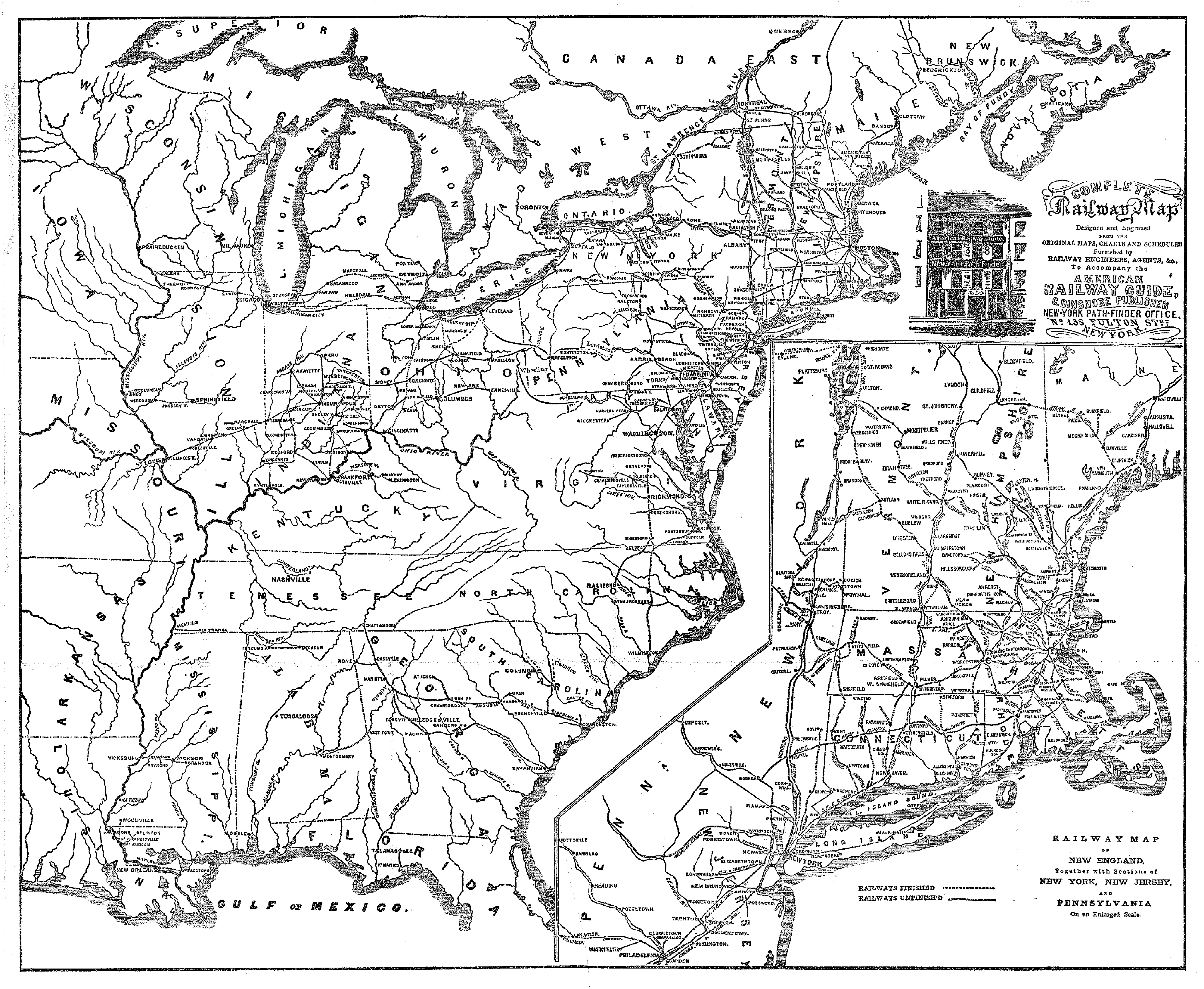
United States railroad map, 1851, from the American Railway Guide. American-Rails.com collection.
Period cost-per-mile figures in Stover’s atlas tradition run higher in the Northeast than in the South: on the order of $39,000 in New England, $46,000 in the Mid-Atlantic, $30,000 in the old Northwest, $24,000 in the South. Those are construction-era averages, not a modern bid. The money came from stock, bonds, towns, states, and, after 1850, federal land.
The land grant and the Illinois Central
The signature federal act of the decade is not a Pacific railroad. It is the land-grant law President Millard Fillmore signed on September 20, 1850: alternate even-numbered sections to Illinois for a railroad from the Illinois & Michigan Canal toward Cairo, with branches toward Chicago and toward Galena/Dubuque, and matching grants to Mississippi and Alabama for the Mobile & Ohio. Stephen A. Douglas shepherded the Illinois piece. The state passed the land to a new company. Governor Augustus C. French signed the Illinois Central charter on February 10, 1851. About 2.6 million acres underwrote the Charter Lines.
Those lines were a Y of about 705 miles: Cairo north to the Mississippi at Dunleith (East Dubuque), 453 miles, and a branch from what became Centralia into Chicago, 252 miles. Centralia took its name from the railroad. The last spike on the Charter Lines was driven September 27, 1856, near Mason, Illinois, inside the time limit in the act. At completion it was twice as long as any other railroad in the world. Cairo still met the Gulf by packet; the Ohio River bridge is 1889. The IC is the first large American railroad built on a federal land grant. Later Plains and Pacific grants copy the idea. The live copy’s list of “granger lines” (Rock Island, Milwaukee, Burlington, Chicago Great Western) mixes 1850s builders with a company that did not yet exist. Rock Island, Burlington, and Milwaukee were in the Midwest in this decade. The Central is the land-grant prototype.
Four trunks
The eastern map of 1860 is already the four-trunk story, even if Chicago is not yet on every letterhead.
The original New York Central Railroad was a consolidation, not a new grade. On May 17, 1853, ten companies between Albany and Buffalo became one road under Erastus Corning. That is the Mohawk and the lakeshore assembled as a single Albany–Buffalo machine. Vanderbilt’s New York Central & Hudson River, Harlem control, and the Water Level Route to Manhattan are the 1860s. Do not put the Commodore in the president’s chair in 1853. The company history is New York Central.
The New York & Erie finished what the 1840s had been building. The original main from Piermont-on-Hudson to Dunkirk on Lake Erie opened May 14, 1851, with President Millard Fillmore and Daniel Webster in the party. That is the live copy’s error: it was Dunkirk in 1851, not Buffalo in 1853, and it was six-foot gauge. Length under one ownership was the boast. Chicago is later. The company history is Erie.
The Pennsylvania Railroad, chartered in 1846, put Philadelphia on an all-rail line to Pittsburgh on November 29, 1852. That first through route still used the state’s Allegheny Portage Railroad planes over the mountain. The PRR’s own mountain crossing and Horseshoe Curve (1854) are the rest of the decade. Pittsburgh was the point: keep Baltimore from owning the Ohio. The company history is Pennsylvania.
The Baltimore & Ohio reached Wheeling on the Ohio on January 1, 1853, thirty years after the 1827 charter, and eight years after it had sat at Cumberland watching the canal. Harpers Ferry, still in Virginia, was already the photogenic gorge. Nathaniel Currier’s 1857 lithograph on this page shows a B&O train heading east over the Potomac with the C&O Canal in the foreground. Compare it with a modern photograph of the same notch. The company history is Baltimore & Ohio.
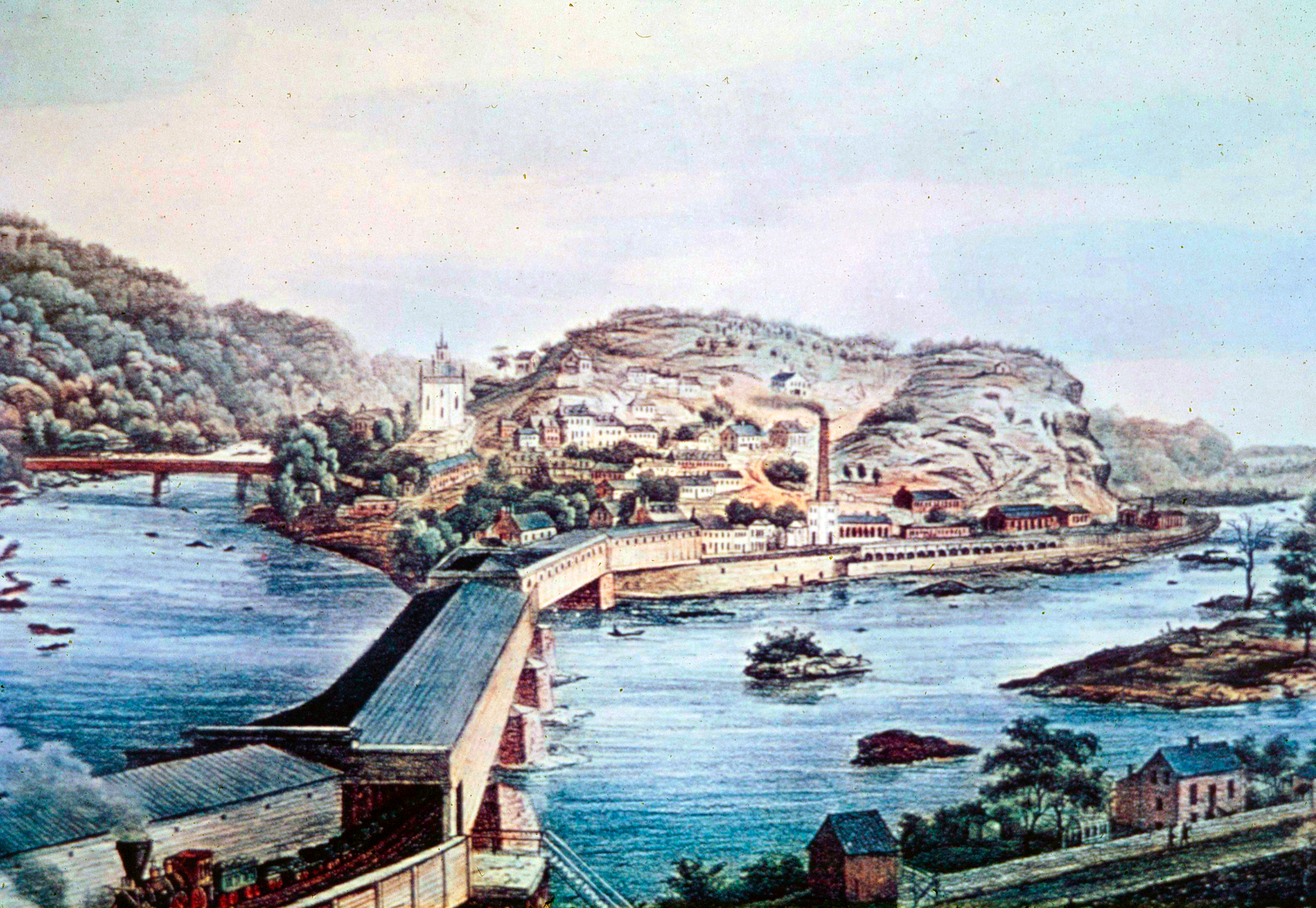
Harpers Ferry, Virginia (now West Virginia), 1857. A Baltimore & Ohio train heads east over the Potomac; the Chesapeake & Ohio Canal is in the foreground. Nathaniel Currier lithograph; Ives joined the firm that year. Author’s collection.
Chicago, the rivers, and east–west freight
Before the railroad, Midwest produce moved with the water: Ohio and Mississippi south to New Orleans. Once rails ran straight west through Ohio, Indiana, and Illinois, the grain and the hogs could go east to New York and Philadelphia without a Gulf detour. Chicago sat on the lake at the place those east–west roads wanted to end, and where a north–south road such as the Illinois Central wanted a lake port. Western companies later chose it as an eastern terminal because the eastern companies were already there.
Texas and the west bank of the Mississippi were no longer empty of rails. The Buffalo Bayou, Brazos & Colorado, among others, was building from the Houston country in 1853. Missouri roads were already west of St. Louis. “Railroads reached across the Mississippi” in this decade means both track on the far bank and, in 1856, a bridge.
The Rock Island bridge
The first railroad bridge over the Mississippi opened in April 1856 between Rock Island, Illinois, and Davenport, Iowa, on the Chicago & Rock Island. River interests treated it as a hazard. On May 6, 1856, the steamboat Effie Afton struck a span and burned. The lawsuit that followed put Abraham Lincoln in a courtroom for the railroad. The legal point was whether a bridge could stand in a navigable river. The railroad point was that the Mississippi would no longer be a mandatory car-to-boat transfer. See Rock Island and bridges. Few other spans of this size existed yet. Limited bridges and mixed gauges are why 1860 still does not look like 1916.
At Niagara, John A. Roebling’s railway suspension bridge opened in 1855: about 825 feet, a little more than two miles below the Falls, Niagara Falls, Ontario, to Niagara Falls, New York. It carried trains until 1897. Currier’s 1856 lithograph is the public image of that crossing.
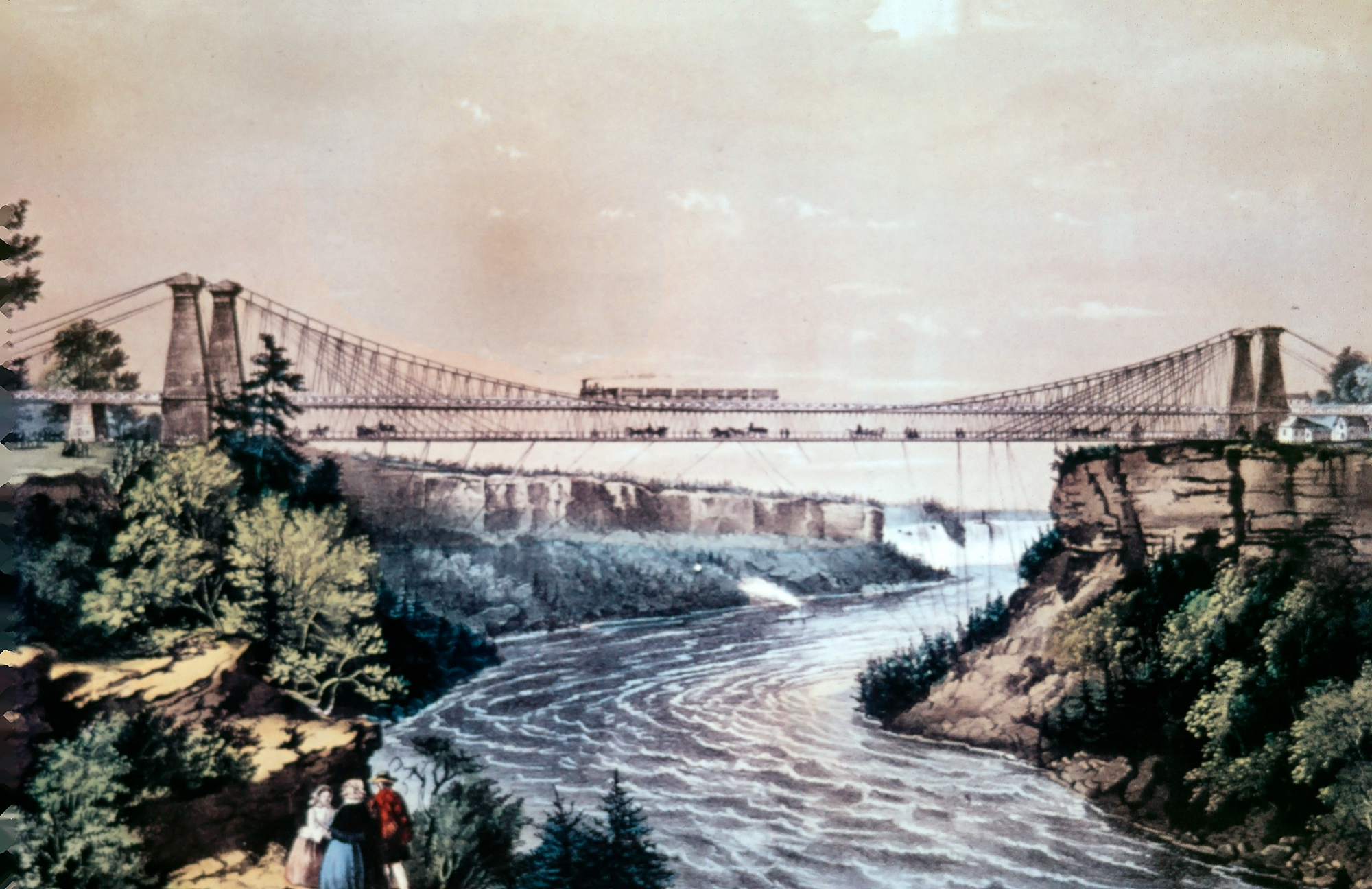
“The Railroad Suspension Bridge.” Nathaniel Currier lithograph, 1856: Roebling’s span at Niagara Falls, about 825 feet, in use 1855–1897. American-Rails.com collection.
Charles Minot, September 22, 1851
Telegraph wire along the right-of-way is can trace its origin to Morse’s public Washington–Baltimore message on May 24, 1844, over the B&O. In 1851, the first train order was sent over this new technology.
On September 22, 1851, Charles Minot, superintendent of the New York & Erie, was on a westbound train waiting at Turner’s (today Harriman, New York) for an eastbound that had not appeared. A commercial telegraph line paralleled the railroad. Minot wired Goshen, fourteen miles west, asked if the opposing train had left, was told no, and wrote the first telegraphic train order in the American record: hold the eastbound at Goshen; run the westbound to Goshen regardless of the opposing train. Engineer Isaac Lewis refused to break the timetable. Minot took the engine himself and went. The story has grown in the telling; the date, the station, and the idea do not. From then on a dispatcher could move a meet. Pole lines and Morse offices followed the track for the next century. That plant is pole lines.
California and the surveys that waited
California became a state on September 9, 1850. Gold had already pulled a population around the Horn and over the Sierra. The first California common carrier of record is the Sacramento Valley Railroad, articles in 1852, Theodore Judah the engineer, first train Sacramento to Folsom in February 1856. A Humboldt Bay lumber tramway, the Arcata & Mad River, is sometimes dated 1854 as the first rails in the state; it was a mill road, not the SVRR’s common-carrier main. Judah’s later Pacific work is the 1860s. Collis Huntington in this decade was a Sacramento merchant, not yet a Central Pacific director. Jay Gould was a young man in New York, not yet a railroad baron. The famouse tycoons mostly begin appearing across the industry after 1860.
Washington did want a Pacific railroad. In 1853 Secretary of War Jefferson Davis sent out the Pacific Railroad Surveys: army and civilian parties along several parallels from the northern plains to the 32nd. The reports (1855) proved that more than one line was possible. Slavery politics kept Congress from picking one. Nothing was graded to the Pacific in this decade. Lincoln’s election, South Carolina’s secession on December 20, 1860, and Fort Sumter in April 1861 close the book. The central route is authorized in 1862 and finished on May 10, 1869. The fabled, first transcontinental railroad.
Sleeping cars, and the 4-4-0 still in charge
The locomotive of the decade was still the 4-4-0. Freight cars were heavier than the 10-ton boxes of 1840, still wood, still link-and-pin. Speeds on good passenger track were no longer a crawl; most freights were. George M. Pullman’s first sleeping car, 1859, was a rebuilt day coach often remembered as Old No. 9: about 40 feet, ten upper and ten lower berths, mattresses, a wood stove, candles, a small toilet. Joe Welsh, Bill Howes, and Kevin Holland, in The Cars of Pullman, are the citation. It was crude next to a later Palace car. It was new next to a sitting-up night in a coach. The Pullman Company and the Pioneer of the mid-1860s are the next decade.
The Panic of 1857
The boom broke in 1857. Banks failed, western land slowed, and railroad securities that had been easy to sell were not. Construction did not stop the way 1873 would stop it, but the easy money of the early 1850s was over. Roads that had been built into empty townships felt it first. The Civil War would restart demand in the North and wreck it in the South. The 1850s close with more miles than any country had ever seen, and with a map that was still two gauges, two sections, and a river too often without a bridge.
By 1860
About 30,600 miles. Four eastern trunks pointed at the interior. Chicago was already the place cars changed. The Illinois Central had shown that Washington would pay in land. A telegraph could move a meet. A bridge could stand in the Mississippi. California had a railroad that was not a rumor. The Pacific was surveyed and not built. The North had the shops, the rail mills, and most of the miles. The Confederacy would inherit about 9,000 miles of a different gauge and a different idea of a network. That imbalance is the opening of Civil War railroads. This decade is how the iron got that far.
Related Reading on American-Rails.com
- Railroad history hub — the national encyclopedia
- 1820s/1830s · 1840s · 1860s · Civil War railroads
- Illinois Central · New York Central · Erie
- Pennsylvania Railroad · Baltimore & Ohio · Rock Island
- Transcontinental railroad · Pole lines / telegraph · Bridges
- 4-4-0 American type · Horseshoe Curve · Tycoons
- Passenger cars · Steam locomotives
Sources
- Stover, John F. The Routledge Historical Atlas of the American Railroads. New York: Routledge, 1999. Mileage 9,021 (1850) and ~30,600 (1860); investment; mid-1850s world-share remark; regional cost-per-mile tradition.
- McCready, Albert L., and Lawrence W. Sagle. Railroads in the Days of Steam. Mahwah: Troll Associates, 1960. $372 million invested by 1850.
- Land Grant Act of September 20, 1850 (Fillmore); Illinois Central charter February 10, 1851; Charter Lines last spike September 27, 1856 (~705 miles; ~2.6 million acres).
- Erie: Piermont–Dunkirk opening May 14, 1851. Charles Minot telegraphic train order, Turner’s (Harriman), September 22, 1851 (Hungerford, Mott, and later Erie commemorations).
- New York Central consolidation May 17, 1853. PRR Philadelphia–Pittsburgh all-rail November 29, 1852 (Portage planes). B&O Wheeling January 1, 1853.
- Chicago & Rock Island Mississippi bridge, April 1856; Effie Afton, May 6, 1856.
- Pacific Railroad Surveys, 1853–55, under Jefferson Davis; reports 1855. Construction is not this decade.
- Welsh, Joe, Bill Howes, and Kevin Holland. The Cars of Pullman. Pullman’s 1859 rebuilt sleeper (Old No. 9).
- Stiles, T. J. The First Tycoon. Railroad as the first large American corporation (context; Vanderbilt’s NYC control is the 1860s).
- Charles R. Wood, The Northern Pacific, Main Street of the Northwest, for the 1853 survey order of business. The NP itself is later.
- American-Rails.com: history hub mileage table; 1840s leaf; Civil War railroads; transcontinental; Illinois Central; Erie; New York Central; Pennsylvania; B&O; pole lines; bridges.
Recent Articles


-
Norfolk & Western Diesel Roster (All-Time)
Oct 12, 26 11:59 PM
 Norfolk & Western diesel roster, all-time. 1,464 locomotives built new for the railroad, from the 1955 GP9s and RS-3s through the C36-7s, plus the merger fleets.
 -
Norfolk & Western Steam Roster (Post 1900)
Oct 12, 26 11:52 PM
 Norfolk & Western steam since 1898. The Roanoke grid: 1,266 locomotives, the J, the A, and the Y, and the last road steam on May 7, 1960.
 -
Norfolk & Western Railway: Map, Logo, Rosters, History
Oct 12, 26 11:45 PM
 The Norfolk & Western, from the City Point Railroad of 1838 to Norfolk Southern. Pocahontas coal, Roanoke steam, and the 1964 expansion.
 -
Louisiana Railroad Museums (2026): A Complete Guide
Oct 12, 26 11:24 PM
 Louisiana railroad museums—the DeQuincy depot, the Long Leaf sawmill, Jackson’s model railroad, and Southern Pacific 745. Confirm hours on each site.
 -
Michigan Railroad Museums (2026): A Complete Guide
Oct 12, 26 11:14 PM
 Michigan railroad museums—Pere Marquette 1225 at Owosso, Durand Union Station, The Henry Ford, and the Mount Clemens depot. Confirm hours on each site.
 -
Mississippi Railroad Museums (2026): A Complete Guide
Oct 12, 26 10:52 PM
 Mississippi railroad museums—McComb’s rebuilt Illinois Central depot and Illinois Central 2542, and the Casey Jones museum at Water Valley. Confirm hours on each site.
 -
The "E2b": PRR's Experimental Freight Electrics
Oct 12, 26 10:33 PM
 PRR class E2b: six GE B-B freight electrics, 4939–4944, 2,500 hp, 11 kV AC. Specifications, roster, and the 1964 scrap.
 -
Alaska Railroad Museums (2026): A Complete Guide
Oct 12, 26 10:10 PM
 Alaska railroad museums—the Museum of Alaska in Wasilla, Tanana Valley No. 1 at Pioneer Park, and the Engine 557 shop. Confirm hours on each site.
 -
Western and Atlantic Railroad: Map, History, Timetables
Oct 12, 26 09:55 PM
 The Western & Atlantic Railroad of the State of Georgia, authorized December 21, 1836, from Atlanta to Chattanooga. The state still owns the 137.33-mile line. CSX leases it. The through railroad opene…
 -
Nashville, Chattanooga & St. Louis Steam Roster (Post 1900)
Oct 12, 26 09:52 PM
 Nashville, Chattanooga & St. Louis steam since 1900. Drury's class grid: Consolidations, 51 Mikados, three 2-8-8-2s, Pacifics, and 25 4-8-4s. Last steam was January 4, 1953.
 -
Nashville, Chattanooga & St. Louis Diesel Roster (All-Time)
Oct 12, 26 09:27 PM
 Nashville, Chattanooga & St. Louis diesel roster, all-time. Switchers from 1941, 37 GP7s, and the F3s and F7s. The quantity column totals 132 locomotives.
 -
Nashville, Chattanooga and St. Louis Railway: Map, History, Logo
Oct 12, 26 08:41 PM
 The Nashville, Chattanooga & St. Louis, the Dixie Line. Charter of December 11, 1845, the Cumberland tunnel, and the Louisville & Nashville merger of August 30, 1957.
 -
Idaho Railroad Museums (2026): A Complete Guide
Oct 12, 26 02:44 PM
 Idaho railroad museums—Nampa’s 1903 depot, Wallace’s Northern Pacific depot, and Boise’s 1925 Union Pacific depot. Confirm hours on each site.
 -
Hawaii Railroad Museums (2026): A Complete Guide
Oct 12, 26 12:50 PM
Hawaii railroad museums—the Hawaiian Railway Society at Ewa Beach and the Laupahoehoe Train Museum on the Big Island. Confirm hours on each site. -
Marietta and Cincinnati Railroad: Map, History, Timetable
Oct 12, 26 11:44 AM
 Marietta and Cincinnati Railroad, chartered March 8, 1845 as the Belpre & Cincinnati. Opened in April 1857, sold under foreclosure December 9, 1882, and succeeded by the Baltimore & Ohio Southwestern…
 -
Tennessee Railroad Museums (2026): A Complete Guide
Oct 12, 26 11:39 AM
 Tennessee railroad museums—TVRM and Southern 4501 in Chattanooga, the Tennessee Central museum in Nashville, Casey Jones in Jackson, and the depots at Cookeville, Cowan, and Townsend.
 -
Virginia Railroad Museums (2026): A Complete Guide
Oct 12, 26 09:40 AM
 Virginia railroad museums—Roanoke’s Virginia Museum of Transportation and the O. Winston Link Museum, the C&O center at Clifton Forge, and the depots in Richmond, Fairfax Station, Suffolk, Parksley, a…
 -
Louisville & Nashville Diesel Roster (All-Time)
Oct 12, 26 12:15 AM
 Louisville & Nashville diesel roster, all-time. Switchers from 1939, the cab units, and EMD, Alco, and GE hoods through the SD50s. The quantity column totals 1948 locomotives, plus 29 yard slugs.
 -
Louisville & Nashville Steam Roster (Post 1900)
Oct 11, 26 05:44 PM
Louisville & Nashville steam since 1900. Drury's class grid: Consolidations, 165 heavy Mikados, 42 Big Emma 2-8-4s, Pacifics, and 22 Mountains. Last steam January 1957. -
Louisville and Nashville Railroad: Map, Rosters, History
Oct 11, 26 05:39 PM
 Louisville & Nashville, the Old Reliable. Charter of March 5, 1850, Milton H. Smith, the 921-mile main line, Big Emma, and the December 29, 1982 merger. Steam and diesel rosters are companion pages.
 -
Oregon Railroad Museums (2026): A Complete Guide
Oct 11, 26 05:19 PM
 Oregon railroad museums—the Oregon Rail Heritage Center, Brooks trolleys, Canby’s 1891 depot, Medford’s Willamette, and Train Mountain. Confirm hours on each site.
 -
Texas Railroad Museums (2026): A Complete Guide
Oct 11, 26 05:15 PM
 Texas railroad museums—Frisco’s Big Boy 4018, Galveston’s Santa Fe depot, Temple’s 1911 station, Plano’s interurban, and Fort Worth & Denver 304. Confirm hours on each site.
 -
Wisconsin Railroad Museums (2026): A Complete Guide
Oct 10, 26 11:51 PM
Wisconsin railroad museums—Green Bay’s Big Boy 4017 and Eisenhower’s A4, Mid-Continent at North Freedom, East Troy’s interurban, and the Riverside & Great Northern. Confirm hours on each site. -
Interstate Railroad (Virginia): Map, Roster, Logo, History
Oct 10, 26 11:22 PM
 Interstate Railroad, a Virginia coal road chartered February 18, 1896. Andover shops. Ten Alco RS3s, 30–39. Southern control in 1961. The company ended October 31, 1985.
 -
North Carolina Railroad Museums (2026): A Complete Guide
Oct 10, 26 11:16 PM
North Carolina railroad museums—Spencer Shops, Wilmington’s Atlantic Coast Line 250, Hamlet’s Seaboard depot, and the New Hope Valley Railway. Confirm hours on each site. -
New Mexico Railroad Museums (2026): A Complete Guide
Oct 10, 26 10:54 PM
 New Mexico railroad museums—Santa Fe 2926 in Albuquerque, the Clovis depot, Alamogordo’s Toy Train Depot, and Belen. Confirm hours on each site.
 -
New York Railroad Museums (2026): A Complete Guide
Oct 10, 26 09:33 PM
 New York railroad museums—Phoenicia, Medina’s New York Central freight house, the Transit Museum, Long Island 35 and 39, and GG1 4933. Confirm hours on each site.
 -
Columbia, Newberry & Laurens Railroad: History, Timetable, Roster
Oct 10, 26 09:08 PM
 Columbia, Newberry & Laurens Railroad, Columbia to Laurens, 75 miles. Chartered in 1885. Five Atlantic Coast Line GP7s, 100–104. Merged into the Seaboard System on April 30, 1984.
 -
New Haven Diesel Roster (All-Time)
Oct 10, 26 06:35 PM
 New Haven diesel roster, all-time. 558 road numbers: 60 DL-109s, 30 FA-1s, 27 PA-1s, 60 FL9s, and the switchers from HH600 0900. Serials and order numbers.
 -
New Haven Steam Roster (Post 1900)
Oct 10, 26 06:31 PM
 New Haven steam since 1900. Drury's class grid: 226 Moguls, 33 Mikados, 50 Santa Fes, 70 Mountains, 141 Pacifics, and 10 Hudsons. Last fan trip July 19, 1953.
 -
New Haven Railroad: Rosters, Map, Logo, History, Trains
Oct 10, 26 06:26 PM
 New York, New Haven and Hartford. The Shore Line, Hell Gate, the 1952 map at 1,838.89 miles, and the railroad Penn Central took at 11:59:59 p.m. on December 31, 1968.
 -
C&O's 4-6-4 "Hudson" Locomotives (Class L): Specs, Roster, History
Oct 10, 26 05:36 PM
 Chesapeake & Ohio Class L 4-6-4 Hudsons. Eight L-2s, five L-1 rebuilds, five L-2-As. Specs, Baldwin works numbers, and the roster. No. 490 survives.
 -
Alton Railroad: Map, History, Timetables
Oct 09, 26 10:31 PM
 Alton Railroad, chartered February 27, 1847 as the Alton & Sangamon. Chicago, St. Louis, and Kansas City, the 1937 Official Guide, and the May 31, 1947 merger into the Gulf, Mobile & Ohio.
 -
Mobile & Ohio Steam Roster (Post 1900)
Oct 09, 26 12:26 PM
 Mobile & Ohio steam since 1900. Drury's class grid: 48 six-wheel switchers, 107 Ten-Wheelers, 15 Consolidations, 58 Mikados, and 14 Pacifics. Last revenue steam October 7, 1949.
 -
Mobile & Ohio Railroad: History, Map, Timetable
Oct 09, 26 11:31 AM
 Mobile & Ohio Railroad, chartered in 1848. Columbus on April 22, 1861, the Cairo & St. Louis, the March 1940 Official Guide, and the September 13, 1940 merger into the Gulf, Mobile & Ohio.
 -
Gulf, Mobile & Northern Steam Roster (Post 1900)
Oct 09, 26 10:42 AM
 Gulf, Mobile & Northern steam since 1900. Drury's class grid: Ten-Wheelers, Mikados, Russian Decapods, Pacifics 425 and 426, and three light 4-8-2s. Last revenue steam October 7, 1949.
 -
Gulf, Mobile & Ohio Diesel Roster (All-Time)
Oct 09, 26 10:41 AM
 Gulf, Mobile & Ohio diesel roster, all-time. The 1935 boxcab, DL-107s, 55 FA-1s, F3s and F7s, the Ingalls 4-S, GP30s through GP38-2s, and 21 SD40s. Serials and order numbers.
 -
Gulf, Mobile & Northern Railroad: History, Rebel Route
Oct 09, 26 10:36 AM
 Gulf, Mobile & Northern, from the 1890 Mobile, Jackson & Kansas City to the Rebel and the September 13, 1940 merger into the Gulf, Mobile & Ohio. Steam roster is the companion page.
 -
Gulf, Mobile & Ohio Railroad: Map, Photos, Trains, History
Oct 08, 26 11:48 PM
 Gulf, Mobile & Ohio, chartered in 1938 and merged September 13, 1940. The Mobile & Ohio, the Alton on May 31, 1947, the Rebel Route, and Illinois Central Gulf on August 10, 1972.
 -
New Jersey Railroad Museums (2026): A Complete Guide
Oct 08, 26 11:37 PM
 New Jersey railroad museums—Whippany, Maywood, Pine Creek, Mahwah’s Erie depot, Phillipsburg, and Boonton. Confirm hours on each site.
 -
New Hampshire Railroad Museums (2026): A Complete Guide
Oct 08, 26 11:34 PM
 New Hampshire railroad museums—North Conway, the Flying Yankee, Ashland, Gorham, Raymond, and Sandown. Confirm hours on each site.
 -
Missouri Railroad Museums (2026): A Complete Guide
Oct 08, 26 11:00 PM
 Missouri railroad museums—the National Museum of Transportation, Patee House, Frisco 4524, the Chicago & Alton depot, and Marceline. Confirm hours on each site.
 -
Milwaukee Road X3800: Deer Lodge’s Shop Goat
Oct 08, 26 04:28 PM
 Milwaukee Road X3800, the a home-built shop goat that served the Deer Lodge, MT yard. It was a 220-volt DC switcher, powered through an extension cord that moved electrics into a roundhouse where the…
 -
Key West Extension (Overseas Railroad): History, Construction, Decline
Oct 08, 26 03:59 PM
 Henry Flagler's Overseas Railroad, Miami to Key West, 1905–1935. The Seven Mile Bridge, the 1935 Labor Day Hurricane, and the road that became U.S. 1.
 -
Florida East Coast Steam Roster (Post 1900)
Oct 08, 26 02:34 PM
 Florida East Coast steam since 1897. Seventeen Ten-Wheelers, twenty Atlantics, eighty-seven Pacifics, ninety Mountains, fifteen Mikados, and the switchers.
 -
Florida East Coast Diesel Roster (All-Time)
Oct 08, 26 02:12 PM
 Florida East Coast diesel roster, all-time. E units from 1939, F3s, BL2s, GP7s and GP9s, the GP40-2 orders, 22 SD40-2s, and 24 ES44C4s. Serials and EMD order numbers.
 -
Florida East Coast Railway: Map, History, Rosters
Oct 08, 26 01:46 PM
 Florida East Coast Railway, Henry Flagler's line from Jacksonville to Miami and Key West. Receivership in 1931, the 1963 strike, Grupo México in 2017, and Brightline on the same track.
 -
Minnesota Railroad Museums (2026): A Complete Guide
Oct 08, 26 10:32 AM
Minnesota railroad museums—the Lake Superior Railroad Museum, Two Harbors, Jackson Street, Willmar’s Great Northern 2523, and Currie. Confirm hours on each site. -
Maine Railroad Museums (2026): A Complete Guide
Oct 08, 26 09:24 AM
 Maine railroad museums—Seashore Trolley, the two-foot lines at Portland, Alna, and Phillips, Boothbay, and the Bangor & Aroostook depots. Confirm hours on each site.
 -
Massachusetts Railroad Museums (2026): A Complete Guide
Oct 08, 26 12:08 AM
 Massachusetts railroad museums—Berkshire Scenic at Lenox, Shelburne Falls trolley No. 10, Edaville, Chatham’s 1887 depot, and Lowell. Confirm hours on each site.