Northwestern Virginia Railroad: Map, History, Timetable
Last revised: October 20, 2026
By: Adam Burns
The Northwestern Virginia Railroad was the Baltimore & Ohio’s line from Grafton to the Ohio River at Parkersburg, and the West Virginia half of the road that later reached St. Louis. Virginia chartered it on February 14, 1851, from the mouth of Three Fork Creek, the junction that became Grafton, to Parkersburg at the mouth of the Little Kanawha. The company organized on August 2, 1851. Trains began on May 1, 1857. The public card of May 17, 1868, measures the branch at 104 miles.
In December 1856 the Baltimore & Ohio agreed to finish the railroad and operate it for five years. The purchase came at a foreclosure sale on February 15, 1865, and the line went on as the Parkersburg Branch Railroad. It stayed the spine of the St. Louis main until CSX moved to take it up in 1985. The North Bend Rail Trail now follows the grade from near Parkersburg to Wolf Summit.
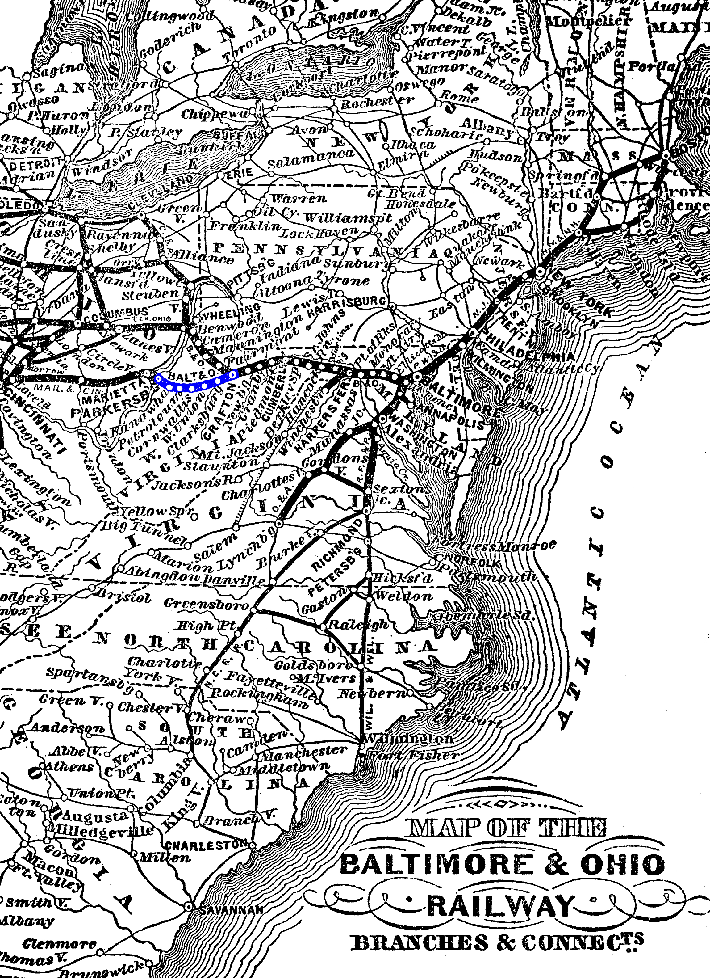
Map of the Baltimore & Ohio Railway, Branches & Connects. The line from the main stem at Grafton through Clarksburg to Parkersburg is marked in blue, with the road continuing across the Ohio toward Cincinnati and St. Louis. The sheet face is undated. American-Rails.com collection.
On this page: At a glance · Charter and the money · Building the line · May 1, 1857 · The Parkersburg Branch · Timetable of May 17, 1868 · The river and St. Louis · Twenty-three tunnels · The clearance of 1963 · Passenger trains · The last trains · The rail trail
At a glance
| Item | Detail |
|---|---|
| Railroad | Northwestern Virginia Railroad, 1851. Parkersburg Branch Railroad after the sale of February 15, 1865 |
| Charter | February 14, 1851. Mouth of Three Fork Creek to Parkersburg |
| Organized | August 2, 1851. James Cook of Parkersburg, president. Peter G. Van Winkle, secretary |
| Opened | May 1, 1857. Grafton to Parkersburg, 104 miles on the card of May 17, 1868 |
| Baltimore & Ohio operation | Five-year agreement, December 1856, to finish the road and run it |
| Tunnels, as built | 23. Twenty-two of them between Parkersburg and Clarksburg |
| Ohio River bridge | January 7, 1871, Parkersburg to Belpre, 7,140 feet. Until then the card’s connection was a ferry |
| Clearance, 1963 | Bores opened from 14 feet 2 inches to 17 feet 2 inches. April into the autumn. $8.5 million |
| Last scheduled train | August 31, 1985, Train 89, Grafton to Parkersburg |
| Today | North Bend Rail Trail, 72 miles, near Parkersburg to Wolf Summit. Grafton to Clarksburg remains in CSX service |
Charter and the money
Parkersburg wanted a railroad while the Baltimore & Ohio was still building its first Ohio River line, the one that ended at Wheeling. The act of February 14, 1851, incorporated the Northwestern Virginia Railroad from the Baltimore & Ohio at the mouth of Three Fork Creek to the Ohio at Parkersburg. To protect that Wheeling line, the charter required the new road to wait a year after the original line was finished before trains could run. The last spike on the Wheeling line went down at Rosby’s Rock on December 24, 1852, and the first through train from Baltimore reached Wheeling on January 1, 1853. The Northwestern Virginia opened on May 1, 1857.
The company’s own account, printed in 1857, says the stock was subscribed principally by residents of Parkersburg and the neighborhood, and that the company organized on August 2, 1851, with James Cook as president. Peter G. Van Winkle of Parkersburg was secretary from that day. He was a lawyer, a member of the Virginia constitutional convention of 1850–51, and later a United States senator from the new state of West Virginia. At the opening of the railroad the same account elects him president as the construction officers stepped aside. The reorganized Parkersburg Branch Railroad appointed him president at its first stockholders’ meeting, on May 10, 1865.
Baltimore supplied the money that built the road. At the first annual meeting, with subscribers from the city now on the books, Thomas Swann was elected president. Swann had been president of the Baltimore & Ohio. The board then mixed the two cities: George Brown, Johns Hopkins, Columbus O’Donnell, William McKim, Charles M. Keyser, Thomas C. Jenkins, and Benjamin DeFord, of Baltimore, with James Cook, John R. Murdoch, and George Neale, of Parkersburg. The principal means, the company said, were bond guarantees of $1,500,000 by the mayor and city council of Baltimore and $1,500,000 by the Baltimore & Ohio, with a further loan from the railroad when the work ran past the first estimates. Benjamin H. Latrobe, chief engineer of the Baltimore & Ohio west of Harpers Ferry, was chief engineer of the new line and surveyed the route.
Building the line
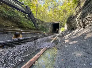
Construction was under way in 1852, working out from Grafton. Robert L. Frey, in the West Virginia Encyclopedia, calls the 104 miles less rugged than the line over the Alleghenies to Wheeling. The country was still a tunnel railroad. Between Grafton and Parkersburg the builders drove 23 bores, all of them timber-lined except Tunnel 10, which was cut in rock. Twenty-two of the twenty-three lay on the roughly 80 miles between Parkersburg and Clarksburg. Tunnel 1, Carr’s or Lodgeville, stood east of Clarksburg, between that city and Bridgeport. Curves were the rule. Only Tunnels 1 and 2 were straight. The bores were about 14 to 15 feet wide.
The longest of the original bores was Tunnel 1, 2,708 feet. Tunnel 6, Doe Run or Central, west of West Union, was 2,297 feet. Tunnel 21, the Eaton bore, was the third of the long ones. In the early 1900s the Baltimore & Ohio put exhaust fans on those three, started by the block operators as a train approached, and kept the fans in service into the 1930s. After the Civil War the timber linings were turned into brick or stone arches. Tunnel 10, the rock bore, stayed unlined. The shortest bore was Tunnel 11, Teneriffe, 176 feet, east of Cornwallis.
May 1, 1857
In December 1856 the Baltimore & Ohio leased the unfinished railroad for five years and took on the job of completing it. Service opened from Grafton to Parkersburg on May 1, 1857. Parkersburg was the company’s second port on the Ohio. Wheeling had been the first. The same spring the Marietta and Cincinnati was opening across southern Ohio, and the connection between the two railroads was a ferry. A Baltimore & Ohio public card of 1868 still says so in a footnote.
The Parkersburg Branch
The five-year lease made the Baltimore & Ohio the operator, and the Northwestern Virginia remained its own company through those years. The road had cost more than the first estimates, and Frey describes it as a financial disappointment until the Civil War, when it became a Union route from the Ohio toward the east. Leaders along the line had already tied their trade to Baltimore. West Virginia was admitted on June 20, 1863, and in that reorganization of the map both the railroad and the town of Parkersburg became corporations of the new state.
The purchase came at the end of the war. On February 15, 1865, at a foreclosure sale, the Baltimore & Ohio bought the property of the Northwestern Virginia. Under the West Virginia statute then in force it became a corporation as to that property by the name of the Parkersburg Branch Railroad Company. The Supreme Court stated the purchase and the name in Baltimore & Ohio Railroad Co. v. City of Parkersburg. The new company’s first stockholders’ meeting, on May 10, 1865, put Van Winkle in the president’s chair, with John W. Garrett of the Baltimore & Ohio among the Baltimore directors. From then on the Parkersburg Branch was a division of the St. Louis main line, Grafton to the river, and the old company name survived as history.
Timetable of May 17, 1868
The card below is headed Baltimore and Ohio Railway, Parkersburg Branch, and dated May 17, 1868. Grafton is mile 279 from Baltimore and mile 104 from Parkersburg. Parkersburg is mile 383 from Baltimore and mile 0 on the branch. Two passenger trains are printed each way. Westbound leaves Grafton at 5:25 a.m. and at 1:40 p.m., and reaches Parkersburg at 10:00 a.m. and at 6:50 p.m. Eastbound leaves Parkersburg at 6:00 a.m. and at 4:30 p.m., and reaches Grafton at 11:15 a.m. and at 9:02 p.m. Footnote 1 is the connection with the main line at Grafton. Footnote 2 is the connection, by ferry, with the Marietta and Cincinnati Railway.
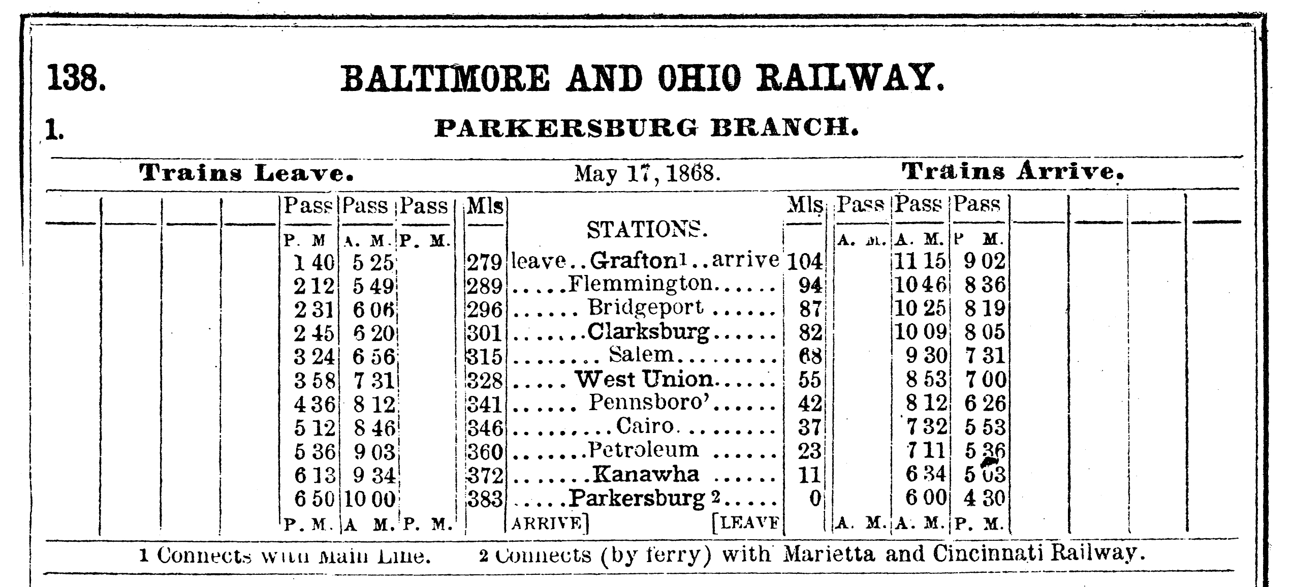
Baltimore and Ohio Railway, Parkersburg Branch, May 17, 1868. Grafton to Parkersburg, 104 miles, with a ferry connection to the Marietta and Cincinnati. The card spells the first station west of Grafton Flemmington. Author’s collection.
| Station on the card | Miles from Baltimore | Miles from Parkersburg |
|---|---|---|
| Grafton | 279 | 104 |
| Flemmington | 289 | 94 |
| Bridgeport | 296 | 87 |
| Clarksburg | 301 | 82 |
| Salem | 315 | 68 |
| West Union | 328 | 55 |
| Pennsboro | 341 | 42 |
| Cairo | 346 | 37 |
| Petroleum | 360 | 23 |
| Kanawha | 372 | 11 |
| Parkersburg | 383 | 0 |
Petroleum is the oil town. The first wells there date from about 1859, and the 1868 card already makes a passenger stop of the field. Clarksburg, 22 miles west of Grafton on this card, and Parkersburg, at the river, were the two cities. Between them the stations are the small towns the trail still names: Salem, West Union, Pennsboro, Cairo. A narrow-gauge railroad, the Pennsboro & Harrisville, connected the county seat at Harrisville with the branch from 1875, and from 1902 it was the Lorama.
The river and St. Louis
Until a bridge existed, freight and passengers for Cincinnati left the cars at Parkersburg and crossed by ferry to the Marietta and Cincinnati. The Baltimore & Ohio built the bridge itself. Construction ran from May 18, 1869, to January 7, 1871, and the bridge opened on that January day. The Historic American Engineering Record, WV-12, gives the length as 7,140 feet. From that day the Parkersburg Branch, the bridge, and the Marietta and Cincinnati were one route from Grafton to Cincinnati.
West of Cincinnati the Ohio & Mississippi, opened in 1857, was the road to St. Louis. It was a six-foot line until 1871. The three railroads, the Parkersburg Branch, the Marietta and Cincinnati, and the Ohio & Mississippi, are the St. Louis main. The Baltimore & Ohio bought the Ohio & Mississippi in 1893 and folded it into the Southwestern in 1900. The name on the employee timetable west of Grafton remained the Parkersburg Branch for the life of the Baltimore & Ohio.
Twenty-three tunnels
Dan Robie’s account of the branch, on WVNC Rails, is the station-by-station record of the line after the company histories leave off. His tunnel list, drawn from the Baltimore & Ohio’s numbers and from Charlene Lattea’s guide to the trail, is the one used here. The railroad numbered the bores. Most of them also carried a name from the 1850s. Lengths are the figures on his chart. Mileposts on that chart are at the east portal and are left off this table.
| No. | Name | Length | What became of it |
|---|---|---|---|
| 1 | Carr’s, also Lodgeville | 2,708 ft as built; 3,236 ft after 1952 | Rebuilt in 1952 as a double-track concrete bore. Still in CSX service east of Clarksburg |
| 2 | Brandy Gap, also Flinderation | 1,086 ft | Clearance increased inside the bore, 1963 |
| 3 | Trough | 282 ft | Bypassed by a cut, 1963 |
| 4 | Buckeye, also Sherwood | 846 ft | Clearance increased inside the bore, 1963 |
| 5 | Shannon | 359 ft | Daylighted, 1963 |
| 6 | Doe Run, also Central | 2,297 ft | Clearance increased inside the bore, 1963. The long tunnel on the trail at West Union |
| 7 | Calhoun’s | 780 ft | Clearance increased inside the bore, 1963 |
| 8 | Cunningham’s | 588 ft | Clearance increased inside the bore, 1963. West end of Pennsboro |
| 9 | Butcher’s | 855 ft | Daylighted, 1963 |
| 10 | Patterson’s | 377 ft | Unlined rock. Clearance increased, 1963. The trail name is Dick Bias |
| 11 | Teneriffe | 176 ft | Daylighted, 1963. The shortest |
| 12 | Section 71 | 577 ft | Clearance increased inside the bore, 1963 |
| 13 | Bonds Creek | 352 ft | Clearance increased inside the bore, 1963 |
| 14 | Section 72 | 182 ft | Daylighted, 1963 |
| 15 | Unnamed | 478 ft | Daylighted, 1963 |
| 16 | Section 73 | 220 ft | Daylighted, 1963 |
| 17 | Unnamed | 452 ft | Bypassed by a cut, 1963 |
| 18 | Section 74 | 963 ft | Daylighted, 1963 |
| 19 | Silver Run | 1,376 ft | Clearance increased inside the bore, 1963 |
| 20 | Linn | 254 ft | Daylighted, 1963 |
| 21 | Bee Tree, the Eaton tunnel | 1,840 ft on the later chart | Original bore collapsed. A new concrete tunnel, 1963 |
| 22 | Rodimer’s | 338 ft | Bypassed by a cut, 1963 |
| 23 | Farrell’s, at Kanawha | 287 ft | Daylighted in 1943, ahead of the clearance project |
Grades on the branch were below the West End, the mountain railroad east of Grafton, and a few of them still exceeded 1 percent. Steam trains were doubleheaded where the tonnage required it. In 1951 the Baltimore & Ohio put centralized traffic control on the branch, postponed from the 1940s by the war, and one dispatcher at Grafton handled the passing sidings. OB Tower at Parkersburg and MD Tower at Clarksburg remained train-order offices into the Chessie years. Six-axle diesels showed up more often as helpers on the grades east of Grafton than as the assigned power between Grafton and the river.
The clearance of 1963
The Chesapeake & Ohio took control of the Baltimore & Ohio on February 4, 1963. The Parkersburg Branch was the direct freight route to Cincinnati and St. Louis, and a trailer on a flatcar or a high boxcar stood above the bores. Robie gives the restricting height as 14 feet 2 inches. The plan was to open the bores to 17 feet 2 inches.
Baltimore & Ohio president Jervis Langdon, Jr., shut the branch to revenue trains for the whole of the job. Beginning in April 1963, traffic moved from Clarksburg to New Martinsville on the Short Line and then down the Ohio River line into Parkersburg. A westbound detour arrived at Parkersburg facing east, and the power had to be run around before the train could go on into Ohio. The same move, reversed, met an eastbound. The job was finished in the autumn, five months from the start, at $8.5 million.
Tunnel 1 had already been replaced, in 1952, by a double-track concrete bore 3,236 feet long and about 34 feet wide. Tunnel 23 had been daylighted in 1943. That left 21 tight bores. Five had the floor lowered, four had the roof raised, eight were daylighted into open cuts, three were bypassed by new cuts, and one, the Eaton tunnel, was drilled new after the original bore collapsed. The nine bores whose clearance was increased inside the original tunnel are the rows marked that way in the table above.
Passenger trains
The 1868 card is a railroad of two passenger trains each way and a ferry at the river. By the time the branch was a piece of the St. Louis main, the overnight train was the National Limited. The daylight train was the Cincinnatian, trains 75 and 76, Baltimore and Washington to Cincinnati, from January 19, 1947. It used shrouded P-7d Pacifics and a five-car Mount Clare consist. On June 25, 1950, the railroad moved it to the Detroit–Cincinnati run, and it left the Parkersburg Branch. The National Limited stayed the St. Louis train.
The Baltimore & Ohio’s last passenger train on the branch was the Metropolitan. Both the eastbound and the westbound made their last stops on April 30, 1971. Amtrak began the next day, May 1. Amtrak’s Shenandoah was the train that later used the branch, and its last run was September 30, 1981.
The last trains
In 1985 CSX moved to take up the Parkersburg Branch, from Clarksburg to Parkersburg, and much of the old Ohio Division. The 1963 work had cleared the line for trailers. Double-stack containers were by then the intermodal car, and the bores stood short of that traffic. Dan Robie records Train 89, on the morning of August 31, 1985, as the last regularly scheduled train. It left Grafton with GP40-2s Baltimore & Ohio 4136 and 4434 and Chesapeake & Ohio 4415, and came into Parkersburg High Yard after 128 years of scheduled trains on the branch.
The rails between Parkersburg and Clarksburg came up in 1988. A CSX work train pulling rail at Cairo that year is the last train Robie’s account places on that part of the line. A stub east of Parkersburg, out to Walker, lasted into the mid-1990s, until the last shipper moved. The stub from Clarksburg west to Wilsonburg lasted until 1999. East of Clarksburg the railroad stayed. Grafton, Bridgeport, and Clarksburg are still on CSX, and the 1952 bore of Tunnel 1 is still a railroad tunnel.
The rail trail
The North Bend Rails-to-Trails Foundation was established in 1989 to hold the grade for a trail. The North Bend Rail Trail is a West Virginia state park of its own, 72 miles from Happy Valley near Parkersburg to Wolf Summit west of Clarksburg, across Wood, Ritchie, Doddridge, and Harrison counties. The state park count is 36 bridges and 10 tunnels, including the 2,297-foot bore at West Union. The path passes North Bend State Park between Cairo and Ellenboro. Refurbished Baltimore & Ohio depots still stand at Salem, Smithburg, and Pennsboro. At Parkersburg the Ohio River bridge and the yard stub remain in railroad service, leased to the Belpre Industrial Parkersburg Railroad.
Related reading
- Baltimore & Ohio
- Marietta and Cincinnati
- Ohio & Mississippi
- Belpre Industrial Parkersburg Railroad
- National Limited
- Cincinnatian
- Shenandoah
- CSX Transportation
Sources
- Charter of the Northwestern Virginia Railroad Company, incorporated February 14, 1851. The company’s own history, printed in the Railroad Record in 1857: the road ran from Parkersburg to the Baltimore & Ohio at the mouth of Three Fork Creek, now Grafton. Organized August 2, 1851, James Cook president, the stock subscribed principally at Parkersburg. Peter G. Van Winkle, secretary from the organization, elected president at the opening. Bond guarantees of $1,500,000 by the City of Baltimore and $1,500,000 by the Baltimore & Ohio. Thomas Swann elected president at the first annual meeting, with the Baltimore directors named in that account.
- Robert L. Frey, “Northwestern Virginia Railroad,” e-WV: The West Virginia Encyclopedia, February 8, 2024. The charter withheld operation until a year after the Wheeling line was finished. Benjamin H. Latrobe, chief engineer. December 1856 lease to the Baltimore & Ohio for five years. Opened May 1, 1857. A 104-mile route. The Baltimore & Ohio assumed the city’s first mortgage in the reorganization that produced the Parkersburg Branch.
- Baltimore & Ohio Railroad Co. v. City of Parkersburg, 268 U.S. 35 (1925). The Baltimore & Ohio purchased the property and franchises at a foreclosure sale in 1865 and, under the West Virginia statute, became a corporation as to that property by the name of the Parkersburg Branch Railroad Company. The sale on February 15, 1865, is the date recited in the record of that tax litigation.
- Tome v. Parkersburg Branch Railroad. First stockholders’ meeting of the reorganized company, May 10, 1865. P. G. Van Winkle appointed president. John W. Garrett among the Baltimore directors.
- Baltimore and Ohio Railway, Parkersburg Branch, public card dated May 17, 1868, sheet 138. Grafton mile 279 from Baltimore and mile 104 from Parkersburg. Parkersburg mile 383 and mile 0. Stations and the two passenger trains each way as printed. Footnotes: connection with the main line at Grafton, and connection by ferry with the Marietta and Cincinnati Railway. The card spells Flemmington.
- Historic American Engineering Record, WV-12, for the bridge length of 7,140 feet. Construction May 18, 1869, to the opening on January 7, 1871, as on the Marietta and Cincinnati page. The Ohio & Mississippi, six-foot gauge until 1871, purchased in 1893 and folded into the Southwestern in 1900, is the account on the Baltimore & Ohio page.
- Dan Robie, “Parkersburg to Clarksburg: Waist of the B&O Main,” parts I and II, WVNC Rails. Twenty-three tunnels, names, lengths, and the 1963 disposition of each bore. Timber lining, later arches, fans on Tunnels 1, 6, and 21. Clearance from 14 feet 2 inches to 17 feet 2 inches, April to autumn 1963, $8.5 million, the Short Line detour by New Martinsville. Centralized traffic control in 1951. Train 89 on the morning of August 31, 1985, GP40-2s 4136 and 4434 and Chesapeake & Ohio 4415. Rails coming up at Cairo in 1988. The Walker stub into the mid-1990s, and the Wilsonburg stub until 1999. Charlene Lattea, North Bend Rail Trail: A Guide to the Trail and Its History, for the 1850s lining, as cited there. Pennsboro & Harrisville from 1875, the Lorama from 1902. Metropolitan last stops April 30, 1971.
- West Virginia State Parks, North Bend Rail Trail: 72 miles, 36 bridges, 10 tunnels, including a 2,297-foot bore. North Bend Rails-to-Trails Foundation, established 1989. Depots still standing at Salem, Smithburg, and Pennsboro are the TrailLink description of the same grade.
- Cincinnatian dates, January 19, 1947, and the move on June 25, 1950, are the account on that page. Shenandoah last run, September 30, 1981, is the account on that page. Chesapeake & Ohio control on February 4, 1963, and the 1985 taking-up of the Parkersburg Branch and much of the Ohio Division, are the account on the Baltimore & Ohio page.
Recent Articles


-
OmniTRAX Adds Tenants at Its Blue Island Hub
Nov 06, 26 10:26 AM
 OmniTRAX has signed new construction-company leases at its 90-acre Blue Island, Illinois, hub and is planning a second phase.
-
Veterans and Active-Duty Members Exceed 16 Percent of Norfolk Southern
Nov 06, 26 10:14 AM
 Norfolk Southern said on November 5, 2026, that more than 3,000 veterans and active-duty service members are more than 16 percent of its workforce. This year grants are $100,000 and $50,000.
-
BNSF: Merger Would Put Half of U.S. Rail Shipments Under One Railroad
Nov 06, 26 10:00 AM
BNSF chief marketing officer Tom G. Williams told customers on November 3, 2026, that a Union Pacific-Norfolk Southern merger would put about half of U.S. rail shipments under one railroad. Nothing is… -
Amtrak Opens a Winter Fare Sale
Nov 06, 26 09:28 AM
Amtrak opened a Winter Wanderlust sale on November 5, 2026. Book by November 12 for travel from December 1, 2026, through March 14, 2027. Blackout dates apply. Coach and Acela Business only. -
CN and CPKC Report October Grain Records
Nov 06, 26 08:50 AM
 CPKC reported October 2026 grain records in Canada and the United States. CN reported 3.54 million metric tonnes across Canada. The releases do not print a combined total.
-
New Brunswick Transload Gets CN Rail Service
Nov 06, 26 08:49 AM
 CN said on November 4, 2026, that it has started serving AD Gagnon Transload Services near Grand Falls, New Brunswick. The site is three kilometres from the Trans-Canada Highway and lists room for 106…
-
Together, Freight and Passenger Rail Can Grow, Union Pacific Says
Nov 06, 26 08:47 AM
 Union Pacific said on November 5, 2026, that passenger obligations would remain if it combines with Norfolk Southern. The capacity claim is a Union Pacific analysis, not a Surface Transportation Board…
-
FM "C-Liner" Locomotives: Specs, Roster, Photos
Nov 05, 26 11:19 PM
 Fairbanks-Morse Consolidation Line cab units, the C-Liners. 165 locomotives, Beloit and Kingston, March 1950 through February 1955. Models, specs, and production rosters.
-
Atlanta, Birmingham & Coast Railroad: Map, History, Roster
Nov 05, 26 12:03 PM
 Atlanta, Birmingham & Coast, from Brunswick and Waycross to Atlanta and Birmingham. Atlantic Coast Line control at the close of 1926. Merged in January 1946 as the Western Division. Steam roster of th…
-
El Paso & Southwestern Railroad: Map, History, Logo
Nov 05, 26 12:00 PM
 The El Paso & Southwestern, the Phelps Dodge copper railroad from Tucson to the Rock Island at Tucumcari. Southern Pacific control on October 31, 1924.
-
Brightline Says Orlando Service Has Resumed
Nov 05, 26 11:55 AM
 Brightline said on November 5, 2026, that trains to and from Orlando have resumed after weather suspensions in Brevard County. Later that morning the departures page still showed the Orlando segment s…
-
Metra Customers Must Sign Up Again
Nov 05, 26 11:43 AM
 Metra says customers who want service alerts must sign up again at metratracker.com. The November 2 story says the new system has launched and the old email list is shut down. A notice on the same pag…
-
Norfolk Southern Packs Six Projects Into One Window
Nov 05, 26 11:38 AM
 Norfolk Southern used one 26-hour window on the W Line for six projects in Indiana and Kentucky, including three bridge replacements. The October 27 account does not give the calendar day of the work.
-
CSX: More Time to Comment on an Inspection Waiver
Nov 05, 26 11:29 AM
The Federal Railroad Administration extended comments on a CSX petition for relief from some qualified mechanical inspector rules until December 2, 2026. The November 2 notice does not grant the waive… -
Brightline Expects Orlando Service on Thursday
Nov 05, 26 09:21 AM
 Brightline said on November 4, 2026, that it expects trains to and from Orlando to resume on Thursday, November 5. South Florida stations kept running. The departures page still showed the Orlando seg…
-
Union Pacific: More Time to Comment on an Inspection Waiver
Nov 05, 26 09:15 AM
The Federal Railroad Administration extended comments on a Union Pacific petition for relief from some qualified mechanical inspector rules until December 2, 2026. The November 2 notice does not grant… -
Wisconsin Opens Comments on the 2027 Freight Plan
Nov 05, 26 09:03 AM
 WisDOT opened the draft 2027 State Freight Plan for comment through December 1, 2026. The plan covers freight rail with highways, harbors, aviation, and intermodal links. Completion is expected in sum…
-
U.S. Rail Traffic Rose 3.5 Percent in the Week Ending October 31
Nov 05, 26 08:52 AM
U.S. railroads moved 514,080 carloads and intermodal units in the week ending October 31, 2026, up 3.5 percent from a year earlier, the Association of American Railroads said on November 4. -
Muni and Bay Area Transit Measures Pass
Nov 05, 26 08:49 AM
 San Francisco Municipal Transportation Agency said on November 4, 2026 that Proposition H and a regional transit measure passed. Proposition H is about 160 million dollars a year for Muni. The regiona…
-
Ground Rules Set for Responsive Applications
Nov 05, 26 08:47 AM
Decision No. 46, served November 4, 2026, denies a request to add Walsenburg to the Union Pacific interchange list and sets what CPKC and CN must include in responsive applications. Four CPKC proposal… -
Video of the Vena Address Must Be Released
Nov 05, 26 08:42 AM
The Surface Transportation Board on November 4, 2026 denied the Union Pacific appeal and ordered the March 17 shipper-conference recording released to the parties by 5:00 p.m. Eastern on November 5. C… -
Chicago & North Western Iron Ore C628s
Nov 04, 26 11:47 PM
 Chicago and North Western C628s 6701-6730, the ex-Norfolk and Western high-hoods, in Upper Peninsula iron-ore service from the mid-1970s until December 21, 1986, and what happened to each unit.
-
Warrenton Railroad: Serving Warrenton, NC (1884-1985)
Nov 04, 26 10:33 PM
 The three-mile Warrenton Railroad, from Warren Plains to the North Carolina county seat. Chartered January 28, 1871. First train November 8, 1884. Closed in 1985.
-
Rio Grande Steam Locomotives (Since 1900)
Nov 04, 26 11:40 AM
 Denver & Rio Grande Western steam locomotives built since 1900. Standard gauge quantity 435 and narrow gauge 48. Challengers, 2-8-8-2s, Mountains, Northerns, and the K-27, K-28, K-36, and K-37.
-
Rio Grande Diesel Locomotives (All-Time)
Nov 04, 26 11:39 AM
 Denver & Rio Grande Western diesel locomotives, each frame once. 554 units, from the 1941 NW2 through the 1990 GP60s. FT, F3, F7, and F9 sets are not counted again under their 1950 numbers.
-
Rio Grande Railroad: Map, Logo, History, Rosters
Nov 04, 26 11:34 AM
 Denver & Rio Grande Western history, from William Jackson Palmer and the October 27, 1870 charter through the Royal Gorge, the Moffat route, the California Zephyr, and Union Pacific common control…
-
Lindblom Gift Expands the Fort Wayne Restoration Shop
Nov 04, 26 11:14 AM
 Art Lindblom gave the Fort Wayne Railroad Historical Society more than $1.4 million, its largest single gift, to expand the New Haven shop. The addition is planned for late 2026 and early 2027. A sepa…
-
Design Contract Awarded for the Forest Park Branch
Nov 04, 26 11:09 AM
The Chicago Transit Board approved a design contract for about 13 miles of Blue Line track from the Illinois Medical District to the I-290 Bridge. The release summary calls it a $17 million contract… -
Kanawha River Railroad: The Norfolk Southern Lease Is Renewed
Nov 04, 26 10:51 AM
 Kanawha River Railroad filed to keep leasing 309.45 miles from Norfolk Southern in West Virginia and Ohio. The second amendment is dated August 17, 2026. The Board has not set the date the exemption t…
-
Short Line Center Awarded a $5.625 Million Grant
Nov 04, 26 10:35 AM
The American Short Line and Regional Railroad Association received a $5.625 million CRISI grant on October 20, 2026, for the Short Line Training Center. A 25 percent match brings the project to $7.5 m… -
Palestine and Rusk Track Rebuild Finishes Its First Phase
Nov 04, 26 09:13 AM
 The Texas & Eastern Railroad has finished the first phase of a roughly $30 million track project between Palestine and Rusk. Phase I used a $13.4 million CRISI grant. Phase II, at $8.54 million, adds…
-
Manhattan, Brooklyn, Queens, and the Bronx Get Subway Power Design
Nov 04, 26 09:12 AM
STV said on November 2, 2026, that MTA Construction and Development selected the firm to manage design of 10 subway substations and 12 circuit breaker houses in four New York boroughs. No contract pri… -
Chicago's Regional Transit Budget Goes Out for Comment
Nov 04, 26 09:07 AM
The Northern Illinois Transit Authority opened its first regional budget for comment through December 4, 2026. The proposal is $5.04 billion for 2027 operations and $9.73 billion in capital work throu… -
VIA Rail Finishes the Toronto Maintenance Centre
Nov 04, 26 09:05 AM
VIA Rail completed a four-year modernization of its Toronto Maintenance Centre on November 2, 2026. The Government of Canada invested $310 million. The shop supports 32 Corridor trainsets and will sus… -
Brightline Suspends Orlando Service for High Water
Nov 04, 26 09:02 AM
Brightline suspended trains between Orlando and West Palm Beach on November 2, 2026, because of high water in Brevard County. A later post the same day kept the suspension until 2:00 p.m. on November… -
Hiawatha West Draws Federal Funding Toward Madison
Nov 04, 26 08:58 AM
 Amtrak welcomed a CRISI selection for Hiawatha West, extending Chicago-Milwaukee service toward Madison, Watertown, and Pewaukee. Wisconsin said on October 16 that the award is over $218 million.
-
Seattle's Train Maintenance Facility Opens for Airo Trains
Nov 04, 26 08:56 AM
 Amtrak cut the ribbon October 23, 2026, on a $250 million Seattle shop for Airo trains on the Cascades route. The building came in on time and $50 million under budget and opens in phases through the…
-
Aberdeen Carolina and Western Wins a $19.9 Million Grant
Nov 04, 26 08:46 AM
 The Aberdeen Carolina and Western Railway won a $19.9 million CRISI grant for about 30 miles of welded rail in Montgomery and Stanly counties. The railroad and NCDOT are putting up a 52 percent match…
-
Alco "C628" Locomotives: Roster, Data Sheet, Specs
Nov 03, 26 07:57 PM
 Alco Century C628: 2,750 hp C-C road switcher, 186 built from December 1963 to December 1968. Production roster, specs, and where the high-hood Norfolk and Western units went.
-
Santa Fe Railroad (AT&SF): Diesel Roster (All-Time)
Nov 03, 26 12:54 PM
 Santa Fe diesel locomotives, each new frame once, with construction numbers and order numbers. The counted total is 3,964, from the 1935 boxcabs through the SD75Ms.
-
Metra Holiday Trains Return on Six Lines
Nov 03, 26 11:40 AM
 Metra holiday trains will run on six lines in December, with tickets on sale at noon November 16 for $10. The Chicago Transit Authority and Pace are fielding holiday buses in the same regional announc…
-
Amtrak Encourages Early Booking for Thanksgiving
Nov 03, 26 11:39 AM
 Amtrak is asking travelers to book Thanksgiving trips early. The railroad carried more than 1.2 million customer trips over the 2025 holiday and expects another record, with extra Northeast Regional s…
-
Channel Pacific Keeps Its West Sacramento Exemption
Nov 03, 26 11:26 AM
The Surface Transportation Board denied a West Sacramento challenge to Channel Pacific Railroad’s exemption to operate about 2,132 feet of terminal track. The exemption took effect in June 2026. -
DART Marks One Year of the Silver Line
Nov 03, 26 11:22 AM
 DART marked one year of Silver Line service linking seven North Texas cities and DFW Airport. The 26-mile regional rail line opened October 25, 2025, as the agency’s first rail expansion in a decade.
-
Massachusetts Breaks Ground for the Berkshire Flyer
Nov 03, 26 10:07 AM
Massachusetts broke ground October 29 in Pittsfield on track work meant to support permanent seasonal Berkshire Flyer service. MassDOT has $31 million for the project in its 2027-2031 capital plan. -
Cheraw Scrapyard Closed After a Search for CSX Rail
Nov 03, 26 10:02 AM
Chesterfield County deputies, CSX police, and state agents searched Cheraw Iron and Metal on October 27 and closed the yard after finding CSX rail and telephone wire. -
Union Pacific Urges the Board to Keep a Speech Video Confidential
Nov 03, 26 09:53 AM
Union Pacific on October 30 asked the Surface Transportation Board to keep a recording of Jim Vena’s shipper speech confidential while it appeals. BNSF on November 2 asked the board to deny that… -
Enfield Station Construction Begins on the Hartford Line
Nov 03, 26 09:39 AM
 Connecticut has started a $125.3 million Enfield station on the Hartford Line, restoring passenger service for the first time since 1986. The state expects construction to finish in fall 2030.
-
Santa Fe Steam Roster (Built Since 1900)
Nov 03, 26 09:30 AM
 Featured here is the Santa Fe's all-time steam roster after 1900. The railroad operated a wide and varied collection of wheel arrangements.
-
Santa Fe Railroad: Map, Logo, History, Rosters
Nov 03, 26 09:16 AM
 History of the Atchison, Topeka and Santa Fe, from Cyrus Holliday’s 1859 charter to the Burlington Northern merger on December 31, 1996. The Warbonnet, the Super Chief, and the Chicago to Los An…